el nino : comparing '97-98 with '15-16 in Niseko

4 Dec, 2015
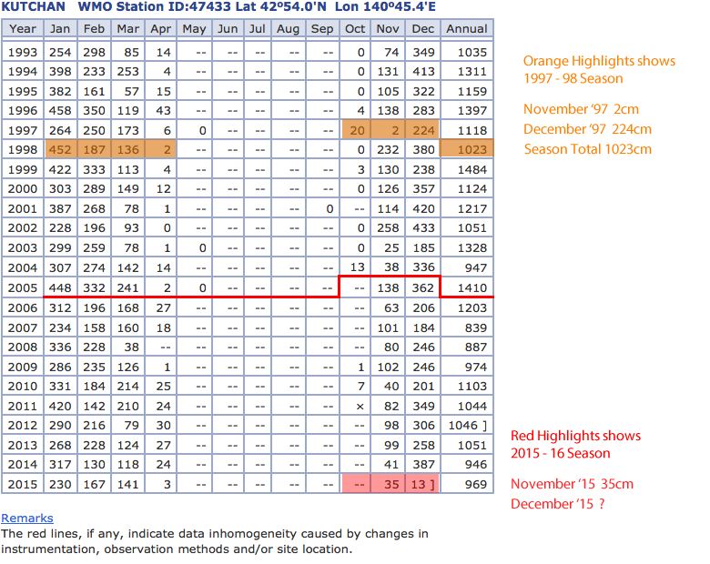
with the rain the other day, which is quite normal btw. we thougth it might be interesting to see how el Nino weather patterns may effect the coming winter and early winter which has already passed. In visitng JMA kutchan snowfall records we took a snap shot of the data (http://www.data.jma.go.jp/obd/stats/etrn/view/monthly_s3_en.php?block_no...) and compared if with the last strong el Nino which was '97 - '98. As you can see not much difference and '97 December was somewhere in the average so I guess we will just have to hold on and go for the ride(s).
It must be noted that the Mountain will get a lot more snow than these figures and villages levels will get a few metres more as shown in our last 2 season records.
Generally it is accepted that the North East Moonsoon wind that comes off Siberia kicks into its strongest in Mid-December and carries through to Mid- February. With 26cm today at our measuring point in Annupuri we are off to a great start. The below screenshot was taken yesterday Friday, December 4 so if you check now the recorded snowfall is at 31cm for the month of December.
elnino97_98_compareto_15_16.gif

